We’re in for a change in our weather pattern as we head into the Labor Day weekend, and unfortunately it’s looking like a pretty active weather period can be expected in the Midwest through early next week.
A warm front lifting out of the south on Friday will signal the change. This front will bring a return of hotter and more humid conditions into the upcoming weekend. But there is good news! Even with the front in the region on Friday, it does look as if we’ll stay dry here in West Central Ohio for the first Football Friday Night of the season. We’ll just have to deal with a little more heat and mugginess.
After a dry first half of our Saturday, ample moisture building in out of the south will bring an increased chance for showers and thunderstorms into the evening and overnight hours. These showers and thunderstorms are NOT expected to be severe but they could bring with them some heavy rain into Sunday morning.
Once that system moves off to our east on Sunday we’ll see a gradual decrease in rain and clouds by the afternoon and evening. My attention will then shift out West where a better chance for severe weather could set up Sunday and Monday.
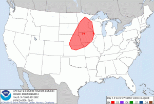
The National Weather Service already has an area highlighted on Sunday in anticipation of a severe weather outbreak.
A couple of very key ingredients are expected to come together on Sunday in the region highlighted above that will help to spark severe storms.
1) Wind Shear
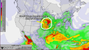
High wind shear is expected over Nebraska, Iowa and Minnesota on Sunday afternoon. Wind shear is basically a change in DIRECTION or SPEED in wind as you go higher up into the sky. The more there is a change in wind direction or speed from the surface and up through the atmosphere, the more chance you have for thunderstorms that will be long-lasting and able to maintain themselves for hours at a time.
2) Instability
High CAPE, or, Convective Available Potential Energy is expected as well in this region on Sunday. The higher the CAPE values, the more primed the atmosphere is for any POTENTIAL thunderstorms.
3) A Trigger
Without some sort of trigger, we could have all the CAPE in the world and it could still be a sunny day. In this case however, the trigger will be a strong cold front pushing through the Midwest that will be able to tap into high CAPE values and good wind shear likely triggering a round of severe weather.
By Monday all of this activity will push east and closer to us here in West Central Ohio. The same ingredients I highlighted above will be in play on Labor Day. As the aforementioned cold front continues to push east it will bring the focus for potential severe weather into parts of Wisconsin, Illinois and Indiana where the best CAPE and Shear will be on Monday. Where you see the cold front, high shear and CAPE come together, that’s where the chance for severe storms will be.
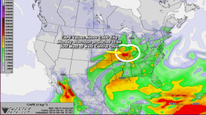
In the graphic below I have circled an area where shear will be high, this is also the region where CAPE values will exceed 2,000 J/kg. Both shear and CAPE will NOT be as high on Monday as it was on Sunday further west. Notice that Western Ohio is not included in the area I have circled.
Here is a look at the CAPE on Monday.
This set up certainly catches my eye especially since it will be closer to West Central Ohio on Monday. As of now it looks as if strong to severe storms will develop late Monday afternoon over Southern Wisconsin and Illinois and then push east into the evening. By the time they would reach West Central Ohio they will be outrunning both better CAPE and shear in the atmosphere. Nonetheless, this is still something to watch late Monday. This system is still four days away and if it speeds up (which is a possibility) that would shift the focus for severe weather closer to home. This is something to keep an eye on over the weekend, I’ll be sure to keep you updated!
-Kyle
If you haven’t yet, be sure to download our FREE Weather App! I use it all the time for tracking storms when I’m not in the office.


