9/8/2014
A strong cold front will move through the region late Wednesday bringing the possibility for severe weather including damaging wind and the threat for an isolated tornado.
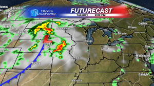
The set up is one that is definitely showing that we’re nearing the changing of the seasons with a MUCH cooler air mass slated to move into West Central Ohio. The system will really gain steam on Tuesday with severe weather a good possibility through Nebraska, Iowa, Southern Minnesota and parts of Wisconsin.
The cold front will continue to push east on Wednesday shifting the threat for severe weather into the Southern Great Lakes.
Some unseasonably strong upper level wind support will accompany this system as it moves in late Wednesday afternoon and Wednesday evening. If you read this blog you have probably heard me talk about “wind shear” and “CAPE” quite often, both being important contributors to severe weather potential. In Wednesday’s case, there will be pretty high wind shear for this time of year with CAPE values that are still in question. Here’s the set up:
Wind Shear
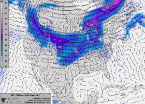
As the cold front nears on Wednesday evening it will have pretty good upper level wind support to help maintain storms that develop along the front. Most forecast models agree with each other and show wind shear values high enough to warrant severe weather potential here in West Central Ohio. Wind shear is either the change in wind SPEED with height or the change in wind DIRECTION with height in the atmosphere. This change of wind through the atmosphere is crucial to building and maintaining severe thunderstorms. Here is a look at where the highest wind shear will be Wednesday evening, the higher shear values are where the darker colors are in this map.
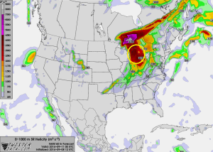
I also look at very low-level wind shear and the chance for the atmosphere to generate LOW level circulation in thunderstorms, this is called Helicity. Helicity values from the surface up too about 1 kilometer in the sky are moderately high Wednesday evening. This is a main reason we could see an isolated tornado or two somewhere in NW Ohio late Wednesday. While our helicty values are progged to be higher than normal, the highest low-level helicity is probably going to stay to our north closer to the are of low pressure moving through the Northern Great Lakes.
CAPE
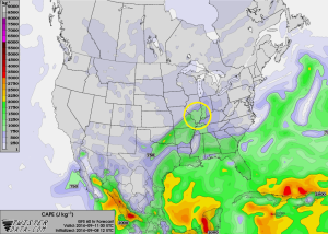
We know that good wind shear will be in place along the front as it moves through West Central Ohio Wednesday, but the CAPE is still in question. CAPE, or, Convective Available Potential Energy is the energy in the atmosphere that is used to rapidly develop thunderstorms. Basically,The more sunshine we get on Wednesday= The higher CAPE values we’ll have to fuel potential severe weather. If you can get a lot of instability (high CAPE) AND high wind shear along a strong cold front then look out! Thankfully, our CAPE will probably be on the low side here in West Central Ohio. But that’s still not to say we’ll completely dodge the bullet.
Most forecast models are showing relatively low CAPE late Wednesday including the GFS shown below. Notice in the graphic that the highest CAPE (which is still pretty low) is off into Southern Indiana and Illinois by about 8 PM Wednesday.
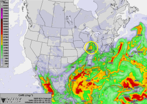
Here is a look at the NAM model at the same time (this one has been a bit of an outlier)
IF, and that’s a BIG if, we can get CAPE values Wednesday afternoon as the NAM is indicating then we have the potential to see a pretty substantial severe weather outbreak for this time of year. Thankfully, as of now, I don’t think that is going to happen. Here’s why:
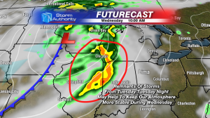
Strong to severe thunderstorms will be ongoing through the midwest into Tuesday night. These storms will weaken and eventually move east towards us here in West Central Ohio. These storms will spread considerable cloudiness over NW Ohio into Wednesday morning/early afternoon.
Notice in the above picture that the storms will be racing out ahead of the better forcing and lift along the cold front by Wednesday morning, along with a loss of daytime heating, this will definitely weaken these storms below severe limits. IF we can stay mostly cloudy with remnant showers from Tuesday’s storms on Wednesday, our atmosphere has a good chance at staying pretty stable (Low CAPE). This is definitely what I’ll be watching most as this cold front nears.
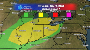
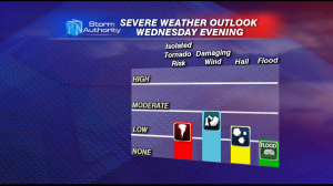
As of now, my forecast is calling for low CAPE and thus a lower severe threat late Wednesday. However, with such high shear values in place, it doesn’t take much destabilization to fire up storms. With that in mind the biggest threat is damaging winds in the 6PM to Midnight timeframe Wednesday evening. Because of pretty good wind shear and low-level helicity, an isolated tornado can’t be ruled out either. Here is a look at how I think the severe weather threat will break down.
These are just my initial thoughts right now. We still have two days until these storms arrive so I will be sure to keep up on the latest forecasts and keep you updated! ALSO, if you haven’t yet, please check out our FREE weather app. With live radar and up to date watches and warnings it’s a wonderful tool to have with severe weather approaching.
Stay tuned!
-Kyle

