**UPDATED** WEDNESDAY NIGHT SEVERE THREAT

6/22/16

Dangerously high winds will be possible tonight here in West Central Ohio along with heavy rain that could lead to flooding and perhaps an isolated tornado or two. This is easily the highest threat for severe weather we have had in 2016 so it would be a good idea to secure any outdoor items and have a safety plan in place as storms move in between about 10 PM and 2 AM Thursday morning.

Let’s get down to the details:

How is this storm going to develop? An area of low pressure and warm front will be moving over Northern Illinois late this evening that will likely spark what is called a Mesoscale Convective System (MCS). As I mentioned in my previous blog post, an MCS is a large and organized area of thunderstorms that typically persists for several hours. They usually congeal or develop into a well-defined bow echo that can bring widespread wind damage to a region. Sometimes MCS’s can be classified as a Derecho, but that doesn’t happen until AFTER the storm has ended based on how widespread and long-lived the wind damage is. Here is where I’m thinking the MCS will develop around 9 PM tonight.

Future 9 PM

The system will evolve and move through Northern Indiana heading towards the midnight hour.
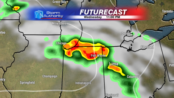
Future 11 PM

And probably enter Western Ohio after midnight.
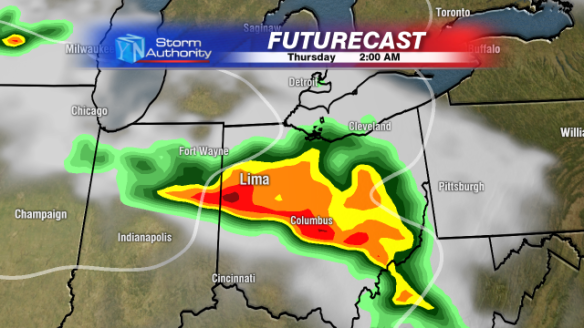
Future 2AM

Other forecast models confirm this arrival time, there has been high consensus among different models giving me pretty high confidence in an arrival time from 11:30PM to 12:30AM into West Central Ohio. Here is a look at another model, the HRRR around 1 AM.
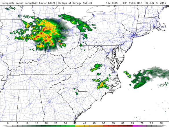
HRRR 1 AM

What can we expect from this storm?

A lot. High wind, heavy rain, and even a few isolated tornadoes. The National Weather Service continues to keep the region under a “Moderate Risk” for severe weather. We don’t see this high of a risk very often, and because of that should be taken very seriously.
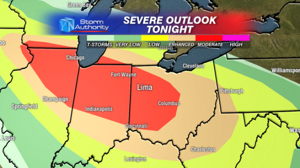
DAY 1 OUTLOOK

How bad will the storm be?

My biggest concern is high winds. Here is a look at the probability of winds over 58 miles per hour within 25 miles of any given point on the map. Notice the black hatched area, that means that within that area the possibility exists to see winds topping 75 miles per hour with storms, that’s hurricane force.
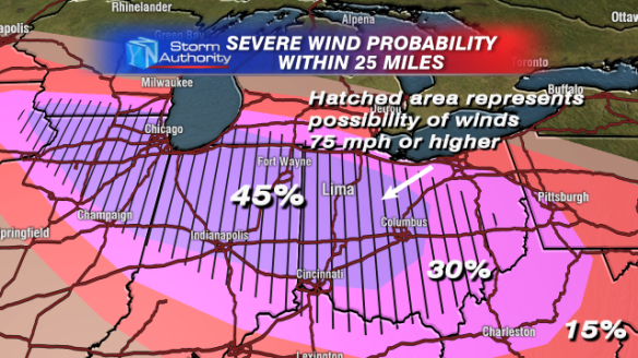
DAY 1 WIND

I’m worried about isolated tornadoes too, but to a lesser extent. Here is a similar probability map but for tornadoes. 5% isn’t very high, but there is definitely a chance that a few storms could spawn a short lived tornado or two.
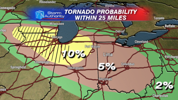
DAY 1 TORNADO

And I can’t forget the rain. We could see lots of rain, especially south of Route 30. Here is a look at the possible rain totals in the region through Thursday morning.
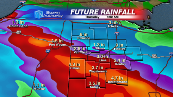
Possible Rain

Again, the timeframe for these storms is in the 10PM to 2AM timeframe. Once the system develops later this evening I will begin to narrow that down. I’ll definitely keep you updated through the evening and stay up to the latest radar with our Weather App!

New App

-Kyle


Wednesday Night Severe Weather Risk

6/21/16

Conditions are coming together for a widespread severe weather outbreak across the Great Lakes Region Wednesday evening into Wednesday night that could impact NW Ohio with widespread high wind. As of now here are the details of what I am expecting to develop but also remember that this will likely be adjusted a bit over the next 24 hours as new data comes in.

As of now, The National Weather Service has placed NW Ohio under a rare “Moderate Risk” for severe weather for Wednesday evening and Wednesday night.

DAY 2 OUTLOOK WIDE

A closer look at the region.

DAY 2 OUTLOOK

Notice that West Central Ohio is right on the edge of the higher risk area, that is because this anticipated Mesoscale Convective System, or, “MCS” will probably develop somewhere over Northern Illinois Wednesday evening and track SE toward Ohio into the overnight hours. An MCS is a large and organized area of thunderstorms that typically persists for several hours. They usually congeal or develop into a well-defined bow echo that can bring widespread wind damage to a region. Sometimes MCS’s can be classified as a Derecho, but that doesn’t happen until AFTER the storm has ended based on how widespread and long-lived the wind damage is. As of now, I don’t feel comfortable saying “possible Derecho” simply because we won’t know until after any damage is assessed.

Here is the set up for the system Wednesday evening. A strengthening area of low pressure will pull a warm front north up into Northern Illinois, Indiana, and NW Ohio late Wednesday evening. This will all develop in a very moist and unstable environment just to the south of the warm front. The area where the potential MCS will develop will likely lie right near the “Triple Point”, or in other words, in the region by the low, cold front, and warm front.

Future Late

It’s important to note here that today’s weather forecast models typically have a VERY hard time forecasting exactly where an MCS will develop. So honestly, it won’t be until the system develops Wednesday evening that we’ll have a much better idea of where it will track. So for now I’m going to assume that it will track along the warm front which will extend into Western Ohio.

Very high wind shear values will be present along the warm front that will allow for this system to maintain most of its strength into the overnight hours as it tracks towards Western Ohio. If there is any silver lining to all of this it is that this system is expected to move through in the 10 PM to 3 AM timeframe, a time not typically best for severe weather. However, I do believe that the wind shear present in the atmosphere will be enough to overcome any loss of daytime heating and help maintain strength.

So here is the bottom line.

High wind will over 60 mph will be very possible with any thunderstorms from about 10 PM to 3 AM Wednesday night. Isolated tornadoes can also spin up along an MCS, but aren’t typically very strong. MCS systems also have the tendency to bring very heavy rain, flooding with this system is definitely a concern as well with over 2 inches of rain possible Wednesday night. Make a plan now to cover or secure anything outdoors Wednesday night and have a plan in place for your family in case warnings are issued. Here is my overall threat outlook.

SEVERE HAZARD OUTLOOK NEW

I will definitely be watching this very closely and update as new data comes in!

-Kyle


Welcome To Mid-Summer! (Sort of…)

5/24/16

Yes I know, we’re still a month away from the official beginning of the summer season but the weather pattern we are going to experience the rest of this week is one more reminiscent of July/August. Basically what we’re dealing with is a VERY slowly moving frontal system that will impact the Plains with several days of possible severe weather. For us, a retreating high pressure system to the south and east will allow a much more humid air mass to build into Ohio.

Set Up

Over the next several days not only will temperatures continue to rise, but so will dew points. Dew point is a measure of moisture in the atmosphere, the higher the dew point, the more sticky it begins to feel outside. Starting Wednesday, dew points are going to rise and stay in the 60’s through the Memorial Day Weekend.

Future Dew Points

Couple those high dew points with temperatures on Wednesday and Thursday in the low to mid 80’s, and you’re going to have a much more uncomfortable warmth here in West Central Ohio.

Future Temperatures

With the added heat and humidity here in Ohio we’ll have the chance for “pop up” showers and thunderstorms pretty much every day this week and this weekend. By no means will any day be a rain out, and the reason for that is because there really won’t be any real forcing mechanism (cold front, warm front, low pressure system) to bring more organized thunderstorms or rain to the region. The better forcing will remain out west through the weekend, and with the better forcing will come the better chance for severe weather.

DAY 2 OUTLOOK

DAY 3 OUTLOOK

As you can see, I am not expecting “pop up” thunderstorms here in Ohio to be severe. But we could see a few storms over the next 4 or 5 days drop some heavy downpours and small hail. Bottom line is that it’s going to be a “rinse, wash, and repeat” forecast through Memorial Day with highs in the 80’s and isolated showers and thunderstorms possible each day!

Have a great night everyone!

-Kyle

New App


Severe Weather Possible Thursday Evening

(3/30/16)

Two rounds of rain will move through West Central Ohio in the next 24 hours. The first round will move through Wednesday night into Thursday morning here in West Central Ohio bringing mainly just rain and possibly a few embedded thunderstorms through noon on Thursday. Once this first round comes to an end early Thursday afternoon, we’ll get a break from the precipitation through most of the afternoon hours. It’s not until Thursday evening that a cold front will begin to approach and we’ll see our chance for some stronger storms. Here is a look at the current severe weather outlook for Thursday, but as far as we are concerned, Thursday evening.

DAY 2 OUTLOOK

The BIG question on Thursday afternoon is how much sunshine we’ll see here in NW Ohio. If we can stay cloudy most of the afternoon and early evening, thunderstorms that develop Thursday afternoon over higher risk areas to the west (see image above) will be moving into a less favorable environment here in Ohio by the time they reach us into the evening hours.

Kyle RPM 12KM Futurecast

There is no doubt that higher instability and better overall conditions for severe storms will be to the southwest of us here in Lima. However, if we can see a couple of hours of sunshine Thursday afternoon and our temperatures warm into the low 70’s our chance for severe storms will increase. For now I’m leaning towards the scenario that we won’t clear out much Thursday afternoon thanks to residual cloud cover from morning rain, this would lessen our chance for severe weather Thursday evening. Even in this scenario, we’re still looking at a decent chance for some damaging winds of 50 mph+ here in West Central Ohio between 5 and 10 PM. Here is a look at Futurecast around 7 PM Thursday evening.

DMA Future Cast And Temps

Wind shear is pretty strong with this system too! Because of that, an isolated tornado can’t be ruled out either in the 5 to 10 PM timeframe.

SEVERE HAZARD OUTLOOK NEW

The bottom line with this system is that we will see rain, wind gusts of over 40 mph throughout the day on Thursday, and the potential for a few severe storms Thursday evening. Be sure to check our Facebook page and our weather app throughout the day on Thursday for updates!

New App


Storms NOT Snow Possible Tuesday Night


2/1/16

Groundhog Day will bring the chance for severe storms to part of the Ohio Valley but there is not a lot of confidence that those storms will make it as far north as West Central Ohio. One thing is for sure though, after another warm up on Tuesday, we’ll see some very gusty wind, rain and maybe even some thunder before the days end.

Here is the set up with a strong cold front lifting through the mid-west. The front will draw up a good amount of moisture out of the Gulf, but will probably struggle to pull it into most of Ohio during the daylight hours. By 7 PM Tuesday the area I have circled will be the area to watch for severe storms capable of producing damaging wind and isolated tornadoes.

Future Tuesday Evening

This lines up very well with the National Weather Service’s outlook for Tuesday.

DAY 2 OUTLOOK

Once the warm front in the image above lifts to our north we will probably feel temperatures jump into the mid to upper 50’s late Tuesday evening.

Future Temperatures

These warmer temperatures will also be accompanied by some of the increased moisture I talked about earlier, but the timing won’t be very good for thunderstorm development being night-time. Nonetheless, some strong wind could accompany rain that moves in late Tuesday evening with wind gusts potentially over 40 mph.

FUTURE WIND GUSTS

In an effort not to drag this one out I’ll end this post by saying that there is a very low threat for strong thunderstorms here Tuesday evening. Isolated wind gusts over 40 mph will certainly be possible, but the overall threat is something I am not concerned with.

SEVERE HAZARD OUTLOOK NEW

With the rain moving in tomorrow please make sure to stay updated with our weather app!

New App

-Kyle

Another Round Of Snow Monday Night

1/11/16

Now we’re into the swing of things! After a couple of inches of snow Sunday morning we’re in for another round of accumulating snow tonight and into Tuesday morning. Our snow tonight will be from a clipper system that will sweep through the Great Lakes.

Clipper Explanation

Snow will begin to move in late this evening around 8 or 9 PM with light to moderate snowfall overnight accumulating around 2 inches by Daybreak Tuesday.

Future Cast Close

Future Cast Close 2

With a dry air mass in place this is very likely going to be a light and fluffy snow that falls tonight. Winds will pick up as the system moves in so that means blowing snow can be expected on Tuesday thanks to the nature of the expected snow. Here is a breakdown of what we can expect out on the roads.

Driving Impacts

I think it’s a pretty good bet that we’ll see around 2 inches of fresh snow by daybreak Tuesday with another inch possible during the day. By Tuesday evening I think most of us will end up with around 2 to 3 inches of snow.

Kyle Snow Totals

I am not a school administrator, but I would bet that you can expect at least a 2 hour delay on Tuesday along with a good possibility of an outright closure for the day because of blowing snow and eventual wind chills below zero into the afternoon. On a scale of 1 to 10 I would rank this system at about a 6 mainly for the bad timing around the Tuesday morning commute. Have that shovel ready Tuesday!

Snow Meter Kyle

REMEMBER, you can keep up with all the latest on our weather app!

New FB App


Accumulating Snow Possible Sunday

1/8/16

The word “snow” seems to have been a lost term thus far here this winter, but over the weekend it looks like we could see some accumulations finally here in West Central Ohio. This snow will be thanks to an area of low pressure moving in out of the southwest on Sunday that will initially bring us rain late Saturday and Saturday night.

Future Wide 2

As the low moves over the state of Ohio it will pull in cooler air behind it switching rain to snow Sunday morning.

Future Wide

Notice in the above graphics that the heaviest snow will likely be over parts of Northern Indiana and Southwest Michigan. There is still the chance that this low could shift its track a bit further east, and if that were the case it would bring the potential for some higher snowfall totals with it, something we’re always paying attention to. By Sunday morning around 7 or 8 AM the rain will probably begin to switch over to snow from west to east here in Ohio.

Future Close

I’m not expecting heavy snow, but with off and on snow showers through the day it looks like we could end up seeing around 1″ of snow for most of us here in West Central Ohio. Where some heavier snow showers fall it’s certainly possible to see closer to 2″. Here is my current snowfall forecast as of Friday afternoon.

Kyle Snow Totals

This definitely isn’t the “big one” but without much snowfall so far this season you’ll want to make sure you’re prepared when you head out this Sunday!

You can also keep up to date on the latest radar and forecasts with our weather app!

New FB App


Wednesday Afternoon/Evening Severe Threat

Here we are almost to the Christmas holiday and I’m writing a blog post about severe weather and NOT snow! But with VERY warm temperatures expected Wednesday, along with the passing of a cold front, there is a low-end threat for isolated severe thunderstorms Wednesday afternoon and evening.

Here is what you need to know.

Set up To even see low chances for severe weather reaching up into Northwest Ohio for this time of year is pretty remarkable. Tuesdays outlook from the National Weather Service has West Central Ohio right on the northern edge of that low risk.

Outlook Wide

And a closer look

Outlook Close

The threat for severe weather will be present thanks to unusually warm temperatures in the mid 60’s along with the approach of a frontal system that will draw up a lot of moisture from the Gulf. This front and area of low pressure will have a lot of support from the jet stream which means very high wind shear will be in place, especially late afternoon and evening. The warm temperatures and high moisture will also allow for low but (still significant for this time of year) CAPE values that will allow for just enough instability to produce thunderstorms.  Here is a look at those CAPE values by about 2 PM Wednesday afternoon. They are definitely low, but really any CAPE this time of year is a bonus for potential severe weather.

CAPE

Notice in the picture above that the higher CAPE values are off to the west in Missouri and Southern Illinois. As the day progresses I’ll be watching to see if that area of higher instability can make it this far east. If it does, it appears the best chance for isolated severe storms will be late in the evening as the cold front nears West Central Ohio.

Timing- As of now the window for our storms appears to be between about 3 PM and 11 PM Wednesday. The threat for strong to severe storms will come in two waves, the first being with a prefrontal area of showers and thunderstorms that will take advantage of increasing moisture and temperatures already in the low to mid 60’s.

Prefrontal Activity

The second line of potential thunderstorms will move in between about 7 PM and 11 PM and it’s this line that I think has the better chance for isolated damaging winds, and to a much lesser extent, perhaps an isolated/brief tornado.

Local 2

Summary- My confidence in severe weather Wednesday isn’t very high. There will certainly be high wind shear in the atmosphere along with a small amount of CAPE, but I just have a hard time believing we’ll see much more than some isolated damaging winds this time of year. Between 3 and 11 PM on Wednesday my biggest concern is isolated winds from 50 to 60 mph and to a lesser extent the chance for a brief/isolated tornado.

Severe Outlook

I’ll be sure to keep you updated as the system moves in! In the meantime you can always track any incoming weather on our weather app!

New App

-Kyle


Severe Weather In The Midwest This Wednesday

11/9/15

A strong frontal system will plow through the middle part of the United States on Wednesday bringing a widespread threat for severe weather across America’s heartland. As of today’s forecasts, here is how the set up is looking for Wednesday.

Wed Set Up Day

Several different ingredients for severe weather will be coming together including a strong cold front and VERY active jet stream helping to stir trouble here on the ground. One thing to notice on the above graphic is that this system will have limited moisture (dew-points) to work with. This is typical for this time of year the further north you are but it doesn’t completely rule out the chance for severe weather, even though typically the more moist the air is the better the overall threat for storms.

Here is the current outlook from the National Weather Service for Wednesday’s potential storms.

SEVERE WED

Notice how the set up graphic above correlates with the outlook. The area where the strong jet stream winds, cold front, low pressure and moisture coincide is where the best chance for storms including isolated tornadoes will be Wednesday afternoon and evening.

All of this activity will head our way Wednesday night with the chance for strong storms here in West Central Ohio. The good news for us is that several factors will work against us getting any severe weather. Here is a look at the potential set up by about midnight on Wednesday night.

Wed Night Severe

We’ll still be dealing with a strong jet stream moving in, so that greatly enhances our chance for strong winds to the tune of 40 to 50 mph. But we won’t have barely any moisture to work with and without higher dew points the atmosphere has trouble becoming unstable, and without that instability storms have a hard time developing and maintaining strength. Here is a look at our projected dew points Wednesday night. Notice the higher dew points staying to the south and west of West Central Ohio. Where you find the higher moisture, that’s where you’ll find the better chance for storms Wednesday night.

Wed Night Dew Point

Looking closer at the severe weather outlook, it’s clear that’s where the better chance for severe weather is as well.

SEVERE WED ZOOM


Having said that, a very strong jet stream can sometimes make up for a lack of instability, but the fact that all this is trying to come together at night has me pretty confident that we’ll very likely just deal with the chance for gusty winds into Thursday morning.

This is definitely something worth watching over the next day or so, but as I mentioned above, I’m not too concerned as of now. Stay tuned!

Also! Be sure to check out our Weather App! It’s great for radar and active watches and warnings!

New App

-Kyle


Remnants Of Hurricane Patricia Move Into Ohio Tuesday

10/26/15

It was just 3 days ago that the entire meteorological world had their eyes on Hurricane Patricia, a hurricane that will go down in history as the strongest ever recorded by the National Weather Service. After making landfall with winds of 165 mph on Mexico’s western coast on Friday evening, Patricia quickly weakened but the massive amount of moisture with this storm carried on into the United States.

Large Patricia

And as you might have guessed by the title of this blog post, all that moisture is headed our way here in West Central Ohio making for a potentially rainy Tuesday and Wednesday. Moisture from this system will slowly push north tonight and Tuesday bringing light rain showers into Northwest Ohio by the early afternoon on Tuesday.

Future 1

Gradually throughout Tuesday evening both rain and wind will begin to pick up. And while neither will be anywhere on the scale of when this system made landfall as a hurricane in Mexico, we are definitely in for our biggest soaker in quite a while after what has been a very dry Fall season. Rain and wind will be the strongest Tuesday night with over an inch of rain possible along with wind gusts around 40 mph possible. Below is the projected radar and wind gusts at 4 AM Wednesday morning.

Future 2

FUTURE WIND GUSTS

Heavy rain Tuesday night will taper off to showers on Wednesday with scattered showers lingering into the afternoon and evening. But it will also continue to be very windy with gusts from 30 to 40 mph into Wednesday night. Here is a look at both the projected radar and wind gusts into late Wednesday afternoon.

Future 3

Winds 3

Needless to say, I think the 24 period beginning Tuesday afternoon through Wednesday afternoon will take care of A LOT of leaves on the trees! We might be spending a good deal of time raking this upcoming weekend 🙂 It will also bring us a good amount of rain, very likely 1″ to 2″ TOTAL through Wednesday afternoon. I don’t think this will make for much of a flood threat other than some localized street flooding from leaves clogging storm drains.

Here is a breakdown of everything outlined above.

Patricia Remnants

And remember to use our FREE weather app on your smart phone to keep up with the latest as all this rain moves in!

New App

-Kyle