(1/29/15)
Forecast models are beginning to show SOME agreement on the potential track of a winter storm across the Eastern U.S. With this potential snow still being nearly 3 days away I just wanted to give a quick update as to what I’m thinking West Central Ohio can expect.
After looking at the data today, ensemble forecasts for both the GFS and the European are beginning to show signals that they are coming into better alignment. You may have heard me refer to ensemble forecasts before, so here is a quick refresher. An ensemble forecast takes into consideration more than one particular model or model run for the day, it blends a gamut of forecasts together and looks for trends. This is important due to the fact that any one single run of a model can be drastically different from the past one, especially when you are talking 3,4 or 5 days out from the actual storm. Showing one snapshot of any model depicting a heavy snow event that isn’t an ensemble far out from the actual storm is usually just speculation and can generally be discredited until a trend starts to show.
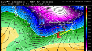
OK, with that said, here is a look at both the ensemble forecasts from the GFS and Euro from this morning. First the European showing the storm Late Sunday developing south of us and generally staying South of the Ohio river. That puts the “target area” for snowfall to the north and east of the low.
Take note in the above picture that there looks to be a strong area of high pressure building into the Northern Plains. A strong high like this could have a significant impact on the track of the low, and as of now, I’m thinking could keep that low subdued far enough to our south here in West Central Ohio to keep us out of the area that will see the heaviest snowfall.
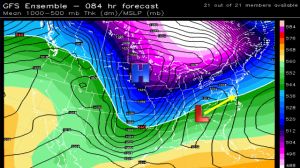
Similar to the Euro, here is the GFS ensemble from today.
The low is in the same general area but isn’t as developed (not as strong) The GFS ensemble from today definitely shows a slightly weaker storm, but again that could still change.
So what am I thinking?
– I have high confidence that we’ll see accumulating snow here in West Central Ohio on Sunday.
– I have low to medium confidence that we’ll see heavy snow upwards of 4 inches over parts of West Central Ohio
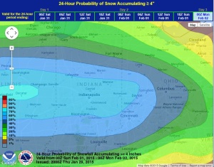
Here is the latest from NOAA showing the probabilities for four or more inches of snow on Sunday.
Bottom Line.
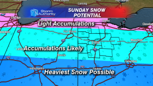
As of now I think West Central Ohio will be right on the northern edge of the heavier snow (accumulations of 4″ or more). In no way am I ready to put specific numbers out there for the region simply because a variation in the track of maybe only 50 to 100 miles would mean a drastically different forecast. For now, I think the heaviest snow will fall from an Indianapolis to Dayton line. As of now, I don’t think this is going to be the “big one” for our winter.
I’ll be sure to keep you updated! Remember to download our free weather app for the latest forecasts and radar!
-Kyle

